Saw & Pond trails
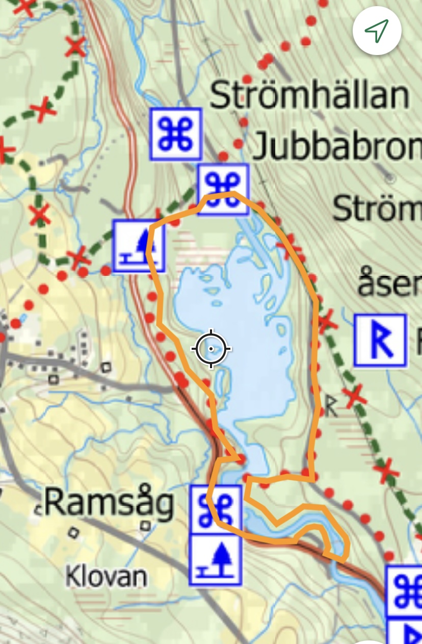
In the fall of 2020, the Svågaleden trail was rerouted
on a stretch near Brännås.
During the marking in 2021, ideas were created
for 2 new routes.
Both start from the old Ram saw
before reaching Brännås.
Either you walk the routes separately
or you can combine both
into a longer route.
Along Svågan you can see the remains of the Flottningen
which continued until 1965.
At Dammrundan You can make
a detour and visit
an old power plant, Strömhällan.
Saw trail.
3-4 short steep hills up and down along
the north side of Svågan.
Good with poles. Same start as Dammrundan.
When you get down to Brännåsdammen
go over to the north side
and then turn off to the right.
The trail follows the river eastwards and follows nicely close to Svågan.
You have to be careful where you put your feet
because beavers have built earthen huts in several places
and there can be holes in the ground.
When the slope gets too close you have to go up the hill
but then it goes down again. Also watch out for the little trolls,
there is a portable hollow tree that you can try to look into
to look for trolls.
The trail comes out onto the paved road
and there you go west towards Brännås over the large bridge.
On the other side, turn right
and follow Svågan again before coming out onto the road again
just before the starting point at Ramsågen.
A description of the Ramsågen is available at the site.
Feel free to walk a bit along the stream in the magical nature.
Length of the trail approx. 2 km


Pond trail.
Follow the paved road north for about 200 m
before crossing it on a smaller gravel road
follow it down towards Brännåsdammen, but turn off just before the
dam and follow a small path towards Brännås.
The path runs along the sand ridge above Svågan.
You can see the water pretty much the whole way on the ridge
and it's like a lake because it's dammed.
The path branches off down to Jubbabron where you cross the river on the north side, but before you do that,
it is a good idea to walk a short distance, about 150 m, along Svågan northwards where you reach Ströhmällan.
Here the river is practically dry because the water is led under the riverbed and comes up below Ströhmällan,
but there are some rills and small pools
that many people use to swim in.
You can also see finely ground holes where stones
have been lying and spinning around in the water and creating these.
When you then cross the bridge, follow a narrow gravel road
back east until the trail turns off onto a nice base road
that leads down to Brännås dam.
Here you have two choices: either you go over the dam and back
to the old sawmill, 2.6 km, or you turn off at Sågrundan
and extend the hike by about 1700 m.
Length of the trail approx. 2.6 km


